 National Parks Journal

Photo: NPS Photo/ Neal Herbert · Public domain
Wrangell - St Elias National Park & Preserve
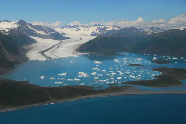
Wrangell-St. Elias is a vast national park that rises from the ocean all the way up to 18,008 ft. At 13.2 million acres, the park is the same size as Yellowstone National Park, Yosemite National Park, and Switzerland combined! Within this wild landscape, people continue to live off the land as they have done for centuries. This rugged, beautiful land is filled with opportunities for adventure.
Entrance Fees
No entrance fee. Other fees may apply for tours, camping, or transportation.
Getting There
Roads and entrances can close temporarily. Check current conditions on nps.gov (opens in a new tab) before you go.
Entrances & departure points
- Directions to Wrangell-St. Elias Visitor Center (Copper Center) (opens in a new tab)
Wrangell-St. Elias Visitor Center (Copper Center)Main
Copper Center, AK · Park always open; visitor center open in summer only (closed mid-September to May)
- Directions to McCarthy Road (Chitina Ranger Station) (opens in a new tab)
McCarthy Road (Chitina Ranger Station)Main
Chitina, AK · Ranger station open in summer; McCarthy Road (60 mi, unpaved) maintained year-round but rough
- Directions to Nabesna Road (Slana Ranger Station) (opens in a new tab)
Nabesna Road (Slana Ranger Station)
Slana, AK · Ranger station open in summer; Nabesna Road (42 mi, gravel beyond mile 4) can have stream crossings
Remote northern access on a gravel road
- Directions to End of McCarthy Road (footbridge to McCarthy and Kennecott) (opens in a new tab)
End of McCarthy Road (footbridge to McCarthy and Kennecott)
McCarthy, AK · Information station open in summer; road open year-round but rough
Remote end of a 60-mile gravel road; cross the footbridge and walk or shuttle to McCarthy and Kennecott
- Directions to Yakutat (opens in a new tab)
Yakutat
Yakutat, AK · Alaska Airlines; local air taxis · Year-round flights; park office hours vary
Remote southeast coast of the park; air or boat only
Airports
- GKN
Gulkana Airport · Gulkana, AK
ClosestSmall airportReeve Air Alaska flies from Anchorage about twice a week. Most visitors fly into Anchorage and drive.
- ANC
Ted Stevens Anchorage International Airport · Anchorage, AK
Major airport
Distances are approximate road distances; tap a distance for live driving directions.
Activities
Top Hikes
8 mi · 250 ft gain · out & back
Relatively level route through lateral moraines to the most accessible glacier in Wrangell-St. Elias with views of Mt. Blackburn.
Starts at: Kennecott Mill Town
9 mi · 3,800 ft gain · out & back
Steep climb from Kennecott to the historic Bonanza Mine at 5,865 feet with stunning glacier and peak views.
Starts at: Kennecott Mill Town
2.5 mi · 300 ft gain · loop
Loop through dense forest climbing gradually along the base of the Crystalline Hills.
Starts at: McCarthy Road
5 mi · 1,800 ft gain · out & back
Through an extinct, deeply eroded volcanic system to a high pass with jagged peaks formed 2-4 million years ago.
Starts at: Nabesna Road
Upcoming Events
No upcoming events scheduled for Wrangell - St Elias National Park & Preserve. Events are updated daily — check back soon or visit nps.gov for the latest.
Best Time to Visit Wrangell–St. Elias
Best time to visit: June–August
The best time to visit Wrangell–St. Elias National Park & Preserve is June–August. The McCarthy Road, Kennecott mine tours, and visitor centers are open during the short summer season.
In those months, average highs are 63–67°F at Kennecott. July is the busiest month on average.
Monthly averages at Kennecott (1,990 ft). Climate normals (1981–2010): PRISM Group, Oregon State University.
Weather & Climate
Varies widely depending on location in park and time of year. Visit https://www.nps.gov/wrst/planyourvisit/weather.htm for detailed information.